3.1 Geographic Information Systems (GIS)
A geographic information system (GIS) is a
spatially referenced database that allows storage, manipulation and
analysis of large volumes of geographic data (Lee 1993). Within the
last decade, GIS has proven to be a useful and valuable decision-making
tool in environmental and ecological modeling. For example, the U.S.
Forest Service has begun an ecosystem management approach' in the evaluation
and use of forest lands (Overbay 1992). In other applications
GIS has been used with remote sensing data for ecological land classification
(MacKenzie 1994) and as a tool for designing temperature buffers for riparian
habitat (Dick 1991).
These types of applications have
given managers and planners of parks, nature reserves and natural resources
new insight into the complex processes of ecosystems. Computer technology
and geographic information software provide the tools and data storage
capabilities to properly analyze and investigate these vital interconnections.
GIS was developed in the mid 1960's mainly
due to the improved storage and processing capacity of computer technologies
(Tomlinson 1985). The concept of geographically referenced
maps had existed prior to this as a way to link "layers" of attribute
information through transparent map overlay (McHarg 1969).
Increased computer memory and faster processing capabilities of large volumes
of information, as well as more powerful and affordable technology, have
allowed GIS to become more accessible to scientists and researchers.
Computer assisted mapping (Berry 1987)
replaced the tedious and time consuming manual overlaying of
thematic layers to produce visual representations of spatial interactions.
A GIS can accommodate many thematic layers and reference them to real-world
coordinates. Map input is usually accomplished by digitizing
points, lines, and areas as polygons within a map extent boundary or by
processing already available maps through scanning or data conversion techniques
(Burrough 1986).
Two data models are used to store the map
data and attributes associated with them (Goodchild 1991). In a vector
data model, points, lines and areas are established by digital input of
x,y coordinates that "trace" the particular feature. Thus, coordinate points
represent a length dimension of 0 and lines equal a length dimension of
1. The connectivity and adjacency of these dimensions represent
a topology' or specific geographic relationship of features and
objects to one another in a 2 or 3 dimensional space (Gatrell 1991).
Areas are closed line segments that represent a dimension of 2. A
third dimension exists when points signify a height or depth (volume).
Computer algorithms determine the association or topological relationships
within the geographical area or region.
Once topology is established, attributes can
be linked' to specific dimensional objects (i.e., points, lines and areas).
For example, in ARC/INFO (ESRI 1996) attributes entered into a tabular
database can be joined' to geographical objects using a common identifier.
This joining of attributes to geographic locations comprises a relational
database structure. In this type of database, items or attributes
can be related to other attributes and their locations subsequently identified
in geographic space.
In the raster data model, a grid or two-dimensional
matrix is super-imposed over the features or, as is the case with remotely
sensed images and aerial photographs, the features are represented by square
pixels or cells. Raster/grid models allow spatial query of columns
and rows using algebraic, logical and statistical functions. Grid cells
represent location within a matrix which can be related to
attribute information, such as x, y or z coordinates. The location
will actually be an areal dimension since each cell is a square of some
specified size. Depending upon the application, raster models may
not represent as precise a location as vector data models. For example,
locating one specific tree in a forest would be best identified
by an exact point in a vector model. However, if the application
required the area of the forest that the tree is located in a raster or
vector model could be used.
Attribute values can be assigned and coded
to grid cells, such as 0 = no data, 1=water and 2 =land surface.
Overlay functions can be performed with grids that represent different
features. An example would be overlaying a grid with cell values
representing soil types on a grid of cell values signifying vegetation
cover. The resulting grid is a correlation of soil type and vegetation
at precise unit locations.
Raster or grid/lattice structures can
represent elevation or surfaces such as digital elevation models
(DEMs) for use in terrain modeling (Lee 1991). A DEM is best described
as a digital representation of an area of the surface of the earth
(Weibel and Heller 1991). In addition to 3D visual representation,
(actually 2.5D since the DEM is visualized on a planar surface such as
a paper map or computer screen) a DEM can be used to model hydrography,
drainage patterns, surface shading or climate change.
The procedure used for establishing the GIS
environment for Quail Hollow State Park was based on the following three
stages of development (after Crain and MacDonald 1984):
1. Assembly and organization of inventory and features of interest
including animal and vegetation habitats, trails, roads, hydrography, land
use and land cover.
2. Analytical operations and criteria evaluation, e.g. land use
identification and analysis.
3. Utilize the GIS as a decision support system for park management,
specifically the Habitat Acquisition Model (HAM).
3.2 Data Quality and GPS
The effectiveness of a GIS depends on the
quality and accuracy of the data acquired for input (Tomlin 1990).
Primary digital data are usually the best choice in that quality
can be known and managed by the user. Primary data are usually
paper maps that can be digitized or scanned for input into a GIS.
Secondary data are available from a number
of different sources including government agencies and private companies.
A widely used secondary data source for elevational information are the
1:250,000 DEMs available via the USGS ftp (file transfer protocol)
sites. USGS DEMs have elevation intervals of 120 meters with
an RMSE (root mean square error) of approximately 15 meters in level terrain
and 30 meters in moderate terrain. In this study user digitized
data were considered more accurate in representing elevation
details, especially since the available DEM from the USGS contained errors
in the area of Quail Hollow State Park. The topographic map
used in construction of the DEM in this thesis was from the Stark County
Engineering Department and has 2 foot, (0.62 meter) contour intervals.
Approximately 100 points per contour line were digitized to sample
elevations accurately.
Another consideration of data accuracy in
this study was related to the geographic coordinates of the study area
for registration of data layers. A GIS database is dependent
on exactness of position on the surface (Cassettari 1993).
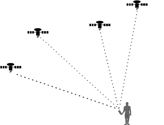
A Global Positioning System (GPS) is a series of satellites
maintained by the U.S. Department of Defense that continually
track their positional accuracy on the Earth's surface (Figure
4). By employing a surface-based hand held GPS unit as
shown in Figure 4, satellite tracking yields
precise on the ground' (i.e., ground-truthed) positions. Examples
of GIS applications using GPS are the registration of land surveys, aerial
photographs, and satellite imagery. While GPS is an extremely effective
tool it can be difficult to use. Signals can be hard to establish
when there is thick cloud cover or even impossible to receive in dense
forest.
GPS was implemented by the U.S. Department
of Defense (DOD) to provide worldwide, all-weather, 24-hour-per-day
geographic positioning and time information (U.S. Department of the
Interior 1993). GPS is a satellite-based triangulation system that
uses measurements of radiowave carrier frequencies and special transmitted
codes. GPS can be used to determine relative distances and geographic
coordinates.
An absolute coordinate system is necessary to tie'
together layers of geographic data to show the correct spatial relationships
of points, lines and areas. Prior to 1960 many maps of natural resource
and land management agencies were created with only relative locations
to known, identifiable objects (U.S. Department of the Interior 1993).
World-wide or absolute coordinate systems were established as a universal
standard for map referencing. These include geographic coordinates (latitude
and longitude) and two plane coordinate systems, Universal Transverse Mercator
(UTM) and the State Plane Coordinate System (SPCS).
A GIS uses a planar coordinate system based
on a map projection. Since the earth is a spheroid, mathematical
conversion calculations are incorporated in GIS software, such as ARC/INFO,
for projecting coordinates of spatial objects into flat maps (ESRI 1995).
GPS coordinates are collected as latitude/longitude, then converted
either as raw coordinates or after they are used as registration of a data
layer. All data layers in this thesis were registered to the UTM
coordinate system.
Many universities and government agencies
now utilize GPS satellite remote sensing technology. GPS is being improved
and made more affordable for use in more general research activities, such
as this thesis. There are a number of GPS units available with prices ranging
from $400 (+-10 meter accuracy) to over $20,000 (sub-meter
accuracy). The latter employs differential correction capabilities,
which is an interpolation of satellite signals received at the field unit,
in conjunction with a base' station which collects signals at a fixed
point.
3.3 Aerial Photography and Remote Sensing
Remote sensing is the science of detecting
and measuring or analyzing a substance or object from a distance (U.S.
Department of the Interior 1993). Aerial photography and other remotely
sensed data, such as satellite imagery, are excellent sources for identifying
vegetation, wetlands, rivers, lakes or other natural resource landscape
patterns. Wildlife habitat can be delineated and typed on aerial
photos, Landsat images or digitally corrected orthophotos.
The first surviving aerial photograph is one
taken by a J.W. Black over the city of Boston, Massachusetts, in 1860 at
a height of 630 meters (Grahm and Read 1986). The new technology
was supposedly used for military reconnaissance in the American Civil
War, 1861-65. In 1898 Colonel Aime Laussedat of the French Corps
of Engineers presented a paper suggesting the use of aerial photos for
preparing topographic maps (Grahm and Read 1986). The invention of
the airplane in the early 1900s expanded the use of aerial photography
to commercial as well as military applications. Air survey
increased dramatically during World War I (1914-1919). Photography
using near-infrared (radiation just beyond the visible spectrum) was first
used during World War II to detect camouflage consisting of dead or artificial
foliage (Grolier 1995). Microwave radiometers were developed from
sensitive radar receivers toward the end of World War II.
There are two basic classes of remote sensors:
active and passive. Active remote sensors transmit some type of energy,
such as an electromagnetic pulse, and detect the energy reflected or returned
from an object. Passive remote sensors depend on emissions or reflections
of energy from natural sources. Cameras are one of the oldest forms
of passive remote sensors. Active remote sensors consist of X-ray
devices, radar and sonar.
Unlike a map, an aerial photograph does not
contain a common scale. Objects on a map have the same scale
because a map is an orthographic projection, i.e. a view projected
along lines perpendicular to both the view and the map surface. A
photograph has a central projection where scale is affected by variations
in terrain, flying height, and focal length of the camera.
Corrections must be made to remotely sensed
data due to the distortion caused by the curvature of the earth's surface
and variables in flight such as roll, pitch and yaw of the sensor vehicle
(i.e. airplane or satellite). Distortion is defined as "any
shift in the position of an image on a photograph that alters the perspective
characteristics of the image" (Warner, Grahm and Read 1996, p.7).
The transformation of photo coordinates
to ground coordinates requires ground control points (GCPs). The
GCPs can be obtained with the use of a global portioning system (GPS) receiver
(see Section 3.2). Coordinates can also be calculated from a reliable
map source, such as the USGS 7.5 minute quadrangles, or from a digital
orthophoto. GCPs are a critical element in converting aerial photography
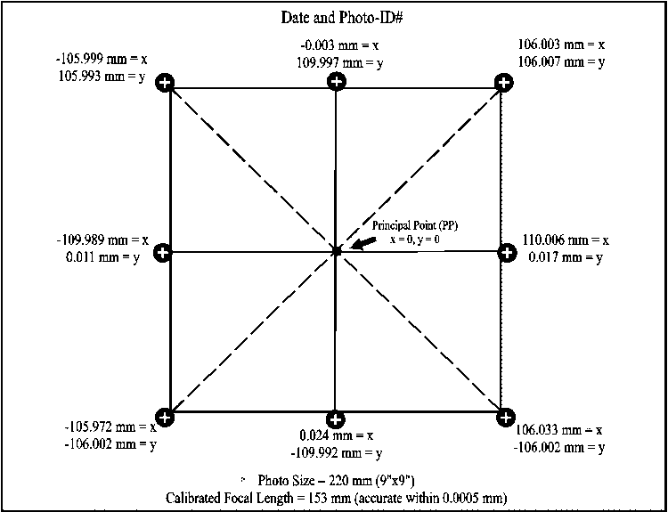
to digitally corrected orthophotos. Most aerial photography contains
fiducial marks which provide a rectangular coordinate system for
measurement of positions on a photo (see Figure 5).
A line drawn from northwest to southeast fiducials
intersects a line drawn from northeast to southwest fiducials.
The central point where these lines intersect is the principal point which
serves as the anchor' point for x,y, and z corrections in the photo.
Each fiducial mark must be referenced to a coordinate obtained from a camera
calibration report.
Digital elevation models (DEMs) are particularly useful for
transformation of imagery to digital orthophotos. DEMs contain elevation
data points that can be interpolated for orthophoto resection and correction
(U.S. Department of the Interior 1993). The resection procedure
determines the position and altitude of an image with respect to the GCPs.
The result of these procedures is a digital orthophoto rectified
and corrected so that each cell or point reference relates to a real-world
geographic coordinate. The final orthophoto can be input to a GIS
for use as a base layer and for further land use analysis.
3.4 Data Acquisition and Conversion
Creating a GIS database involves the acquisition
and conversion of various primary and secondary data types and formats.
Planning the database is a critical process if data accuracy and compatibility
is to be maintained. Many GISs have never been implemented due to the lack
of planning or even ignorance of the availability and format of data (Dymon
1994). While the number of failures due to this problem are
seldom reviewed the successes are well documented.
Spatial data have been available in various
formats for many years. Most familiar are data from large government
agencies such as the United States Geological Survey (USGS) and state agencies
such as the Ohio Department of Natural Resources (ODNR). Digital
data were available in the past only if purchased from these agencies.
Now, with the success of the Internet, much data can be downloaded via
the ftp (file transfer protocol) sites. A number of private businesses,
such as Environmental Systems Research Institute (ESRI), also offer free
data through the Internet. Data sharing has become an important resource
as well. Agencies such as the ODNR are very open to providing digital
data at minimal cost or in exchange for other data.
There is still a matter of processing this
free' data correctly. In the case of U.S. Bureau of the Census
spatial data such as the TIGER (Topologically Integrated Geographic Encoding
and Referencing), USGS GIRAS (Geographical Information Retrieval and Analysis)
and DEM files, the format must be altered by a program before they are
useful input to a GIS (Tomlin 1990). Data conversion is not only
a computing or programming skill, it has become an art. There are
many options and solutions for data conversion problem-solving but intense
practice and training are necessary. Inacurate processing and misuse
of data can produce incorrect evaluations and results. Liability
and legal problems can occur if errors in data precision are proven to
be the cause of costly decision error (Goodchild 1993).
Data integration is "the combination of data
bases or data files from different functional units of an organization
or from different organizations that collect different data for the same
features" (Huxhold 1991). Data sources must be compatible for
a GIS database to be useful. In many cases, data from different agencies
or businesses are in opposing formats. Image and remotely sensed
data are usually in raster format, but many local governments
maintain property boundary and ownership data in vector format.
Appraisers and engineering departments that
maintain tax or parcel information usually use CAD (Computer Aided Design)
software programs which can register line coverages for correct distance
and geographic referencing but cannot link the coverage to attribute databases
(Montgomery and Schuch 1993). CAD files stored in DXF (digital exchange
format) can be converted into the format of the GIS software ARC/INFO.
3.5 Identifying Landscape Patterns
Establishment of land use patterns within
parks and surrounding areas is necessary when planning new land acquisition.
Boundaries of land that might enhance park habitats must be identified
and analyzed to determine any beneficial or negative impacts on wildlife,
vegetation, and wetland communities (see Appendix B for definitions
of terms in ecology; e.g. habitat, wetland, etc.). Land
acquisition decisions are not simply a matter of adding new land, but choosing
the areas that can enhance the biodiversity within the park reserve.
The U.S. Congress Office of Technology Assessment (1987) defined
biodiversity as "the variety and variability among living organisms,
and the ecological complexes in which they occur." Landscape
ecology and nature reserve design are examples of scientific disciplines
that examines habitat patches and corridors at a landscape scale. Theories
of landscape ecology and nature reserve design address issues of
biodiversity maintenance within ecological landscapes and ecosystems.
Haeckel defined the term ecology as the interaction of biotic (living)
and abiotic (non-living) components within the environment (as given in
Schreiber 1990). These components form a complex ecological
community. The interrelationships that these ecological communitites
form with their environment is considered to be an ecosystem.
Tansley (1935, p.285) defined ecosystem as;
"...the whole system (in the sense of physics), including not only
the organism-complex, but also the whole complex of physical factors forming
what we call environment of the biome...the habitat factors in the wildest
sense...it is the systems so formed which, from the point of view of the
ecologist, are the basic units of nature on the surface of the earth."
The word landscape was probably first used
by A. von Humboldt, a German geo-botanist and physical geographer in the
early 19th century. The origin of the word landscape comes from the
Dutch word landschap. The similar word in German is Landschaft and
both meanings suggest an area in space (Zonneveld 1990).
In the 1930's, Carl Troll, a German geographer and ecologist, talked
of landscape ecology as the "consideration of the geographical landscape
and of the ecological cause-effect network in the landscape" (Troll
1939). Troll's concept of linking ecology and geography was further supported
by H. Leser who used the words bioecology and geoecology to
describe the physico-geographic elements within landscape research
(Schreiber 1990).
Within the last decade, landscape ecology
has been embraced in the United States as a transdisciplinary science enhanced
by the increased interest in geographic information systems. Initial
activity in the U.S. began with a National Science Foundation (NSF)
funded workshop in 1983 organized by P.G.Risser, J.R. Karr and R. Forman
who brought together 25 ecologists and scholars to develop guidelines for
the new discipline (Forman 1990). Currently landscape ecology is
being embraced by environmentalists, foresters, geographers and urban planners.
Three perspectives of current landscape ecology
are:
1. Landscape scenery which relates to the original Dutch word
pertaining to landscape paintings. The visual and aesthetic elements
are of main importance.
2. Chorology which refers to the horizontal patterns and individual
patches of landscape attributes of geology, soils, and vegetation.
3. The ecosystem which includes the physical, biological and
noospherical (in the mind), factors of the holistic landscape
(Zonneveld 1990).
The general accepted idea of landscape today is the "characterization
of the physiographic, geological and geomorphological features of the Earth's
crust (Naveh and Liebermann 1994).
Landscape ecology examines not only the physical
features of the landscape but the anthropogenic effects as well and the
intimate interactions and responses of wildlife, vegetation and other ecosystems.
Within a regional concept, environmental conditions such as precipitation
and temperature obviously have an effect on these systems (Thorne
1993). Humans or animals within landscapes are considered landscape
elements. The effects on the landscape by the movements of these
elements are a consideration in management planning and strategy.
Remote sensor data such as aerial photography
or satellite imagery is an excellent source for use in identifying landscape
patterns. GIS applications using remote sensing technology
has produced a rapid increase in landscape analysis research (Allen 1994).
Vegetation, open fields, rivers and lakes are easy to locate on most remotely
sensed data. Many man-made features such as roads, buildings, agricultural
use and cities are clearly identifiable on aerial photography or imagery.
3.6 Ecological Greenways
Fragmented landscapes are the result of developments
and human modifications which can disrupt the natural succession of vegetation,
wetlands and animal habitat. "Ecological greenways" (Smith 1993)
such as parks, scenic sites and other nature reserves, provide the continuity
for these sensitive systems. However, truly natural systems
can benefit from some form of human control or interaction in the form
of management and preservation. This necessitates foresight and planning
when considering additions or changes to ecological systems.
A landscape can be viewed as "heterogeneous
land area composed of a cluster of interacting ecosystems that is repeated
in similar form throughout" (Forman and Godron 1988). Biodiversity
is a necessary component of these heterogeneous systems. If
habitats are fragmented or disrupted then species become isolated and reproduction
cycles may be affected. Natural disturbances, such as fires or floods,
may affect populations in the short term, but many species have adapted
to these disruptions and may actually depend on them (Noss and Cooperrider
1994). Examples are species that require grassy areas that are
replenished by fire. It is actually the disruption of these natural
disturbance regimes that can have a negative effect on species biodiversity.
Theories of nature reserve design attempt
to address the implications and concerns of habitat fragmentation on natural
or environmentally sensitive areas. Ecotones or edge areas are especially
important for many organisms and are usually characterized by high biological
diversity (Holland and Risser 1991). Agricultural areas adjacent
to a reserve or park boundary may be susceptible to development and
urban encroachment could constrain wildlife movement, destroy sensitive
bird habitat for nesting, or environmentally sensitive areas. Ecotones
or edge areas are especially important for many organisms and are usually
characterized by high biological diversity (Holland and Risser 1991).
Agricultural areas adjacent to a reserve or park boundary may be
susceptible to development and urban encroachment could constrain wildlife
movement, destroy sensitive bird habitat for nesting, or eliminate wetland
areas.
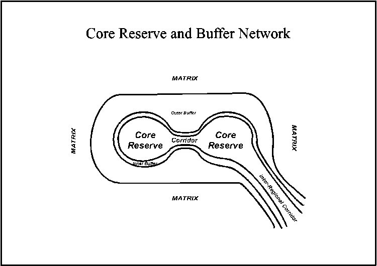
Parks and preserved "green" areas can be managed as "core reserves"
(Noss 1993), with buffered corridors or linkages that connect them to other
nature reserves as shown in Figure 6. The wilderness
network will eventually circumvent the region and dominate the landscape.
Managing the reserve can be approached in many ways.
Flora and fauna activity and habitats can be identified and classified
into compartments (Quail Hollow State Park Management Plan 1993).
Determination of the reserve areas for protection priorities should focus
on species habitat, examples of natural communities and identification
of landscapes compatible with management for conservation and human use
(Scherff 1995).
Quantitative measures of changes and impacts
on wildlife habitat are difficult to determine. Observations of a)
occurrences of rare and endangered species and b) changes in the population
size and diversity of common species are indicators of possible species
isolation (Keyes 1976).
Land cover and land use surrounding core reserves
can be analyzed and modeled to identify patches or land parcels that may
be suitable as buffers, corridors or increased habitat area. It is
necessary to design these models based on real-world locations and accurate
spatial parameters.
Finally, the importance of landscape analysis
and planning is stated as; "To enhance the ecological integrity of the
landscape and achieve sustainable land use, landscape planning should consider
natural and social processes and their spatial relationships in a comprehensive
way" (Langevelde 1994, p. 27).
3.7 Land Acquisition
Conservation of sensitive or unique habitats
, and parks or nature reserves is easier if these areas are connected (National
Research Council [NRC] 1993). The knowledge of the various elements
of landscape ecology brings up the questions of how to accomplish the interconnection
or reconnection of habitats and/or ecosystems. A logical approach
to connecting reserves to enhance biological diversity is the process of
land acquisition of suitable habitat areas.
The NRC states that "usually acquisitions
that provide corridors, connections and linkages between similar landscapes
and habitats are enhanced in biological value....habitats in proper configurations
can facilitate the persistence, movement, and dispersal of native biota"
(NRC 1993, p. 203). The term acquisition' does not only mean buying
land outright. Options include purchase or allowance of conservation
easements, land exchange and exercising eminent domain'. Eminent
domain is defined as the "right of a government to take private property
for public use by virtue of the superior dominion of the sovereign power
over all lands within its jurisdiction" (Webster's 1996).
Many environmental laws have been enacted
in the last 25 years that address the need for land acquisition to preserve
natural areas. Examples are the Uniform Relocation and Acquisition
Policies Act of 1970, The Endangered Species Act of 1973, the Wild
and Scenic Rivers Act of 1968, and the National Trails System Act of 1968
. Federal agencies have established acquisition policies such
as the U.S. Fish and Wildlife Service (USFWS) Land Acquisition Priority
System (U.S. Department of the Interior 1983), and the Bureau of
Land Management (BLM) Federal Land Policy Management Act of 1976.
The land acquisition process requires an extensive
search for candidates and careful considerations of benefits and costs.
Extensive information and data are necessary to determine parcels or areas
for acquistition. GIS technology is a valuable tool for storage and
manipulation of large databases containing land use, landvalues or ownership
information. The effectiveness of a GIS depends on the "adequacy
of exisiting data and upon maps of ownership, inventories, population trends,
and species distributions" (NRC 1993 p.8).
Some data may be available from county or
local governments but data from different agencies are often in varying
formats. The data may be in vector or raster formats
which requires speciality GIS software for processing, such as ARC/INFO
(ESRI 1996) , INTERGRAPH (Intergraph Corp., Huntsville, Alabama) or ERDAS
(Erdas Inc., Atlanta, Georgia). Data often contains inaccuracies
that hinder the conversion process or even makes it unusable.
It is important that the user have expertise and training in the data conversion
techniques as well as other GIS concepts. Data can be expensive to
acquire if it requires scanning or digitizing from paper maps. There
are numerous data for sale already processed but it is often expensive.
For example, a single satellite image (scene) can cost up to $4,000.00.
Other data can be acquired free via the Internet, such as USGS or ODNR
data (see section 3.3).
Additional information for land evaluation
and acquisition criteria can be evaluated with remote sensor data, such
as digitally corrected orthophotos or satellite imagery. An example
are the SPOT multispectral images. SPOT is an acronym for Satellite
pour l'Observation de la Terre--a commercially successful series of French
Earth-observation satellites. Narumalani and Carbone (1993)
used SPOT images to classify land cover as scrub/shrub, forest, wetland
forest, wetland marsh, water, urban and agricultural use.
A set of criteria is needed to establish areas
for acquistion. Information that is gathered often pertains to acreage,
location, price per acre and total cost (NRC 1993). An example of
specific environmental criteria is the USFWS Land Acquistion Priority System
(U.S. Department of the Interior 1983). LAPS outlines five target
areas as criteria:
1. Endangered species
2. Migratory birds
3. Significant biological diversity
4. Nationally Significant wetlands
5. Fishery resources
The Nature Conservancy (TNC), a private land
trust, uses a system of element occurrences (EO) and core rankings
for determing land acquistion priorities. An EO is any type of
biological or ecological entity, e.g. species or community, in a geographic
area (TNC 1987). The rankings are at a global (G), national (N),
or state (S) level. EOs at each of these levels receives a ranking
from 1 to 5, with 1 being the most critical and 5 being least critical.
An example ranking would be S1, which would designate a critical
EO at the state level.
A system of coarse and fine filters' classifies
the EOs by community (coarse filter) and individual species and where they
occur (fine filter). This system was refined by evaluations from
Noss (1987) so that the coarse filter considered 1) disturbance and regeneration
patterns, 2) landscape mosaics, and 3) surrounding habitat and corridors.
These criteria are based primarily on the
goal of protecting biological and ecological diversity. To achieve
this objective Natural Heritage inventory programs were established in
all 50 states. Natural Heritage programs collect, manage and use
biological, ecological and related information in cooperation with various
state agencies. For this thesis, Natural Heritage data of endangered
species was used to identify critical habitat within Quail Hollow State
Park for identifying suitable habitats outside park boundaries.
3.8 Literature Review Summary
Management and park planning requires consideration
of many environmental, social and economic factors. Concerns
have focused on preservation of the environment and responsible land stewardship
for the past 20 years and this trend is likely to continue due to public
concerns for the environment. Focused and informed decision-making
relies on the use of advanced and current technological tools to assist
in the evaluation and analysis of complex
ecological relationships and land use patterns.
An established science that examines spatial
interactions of vegetation, animal populations and human impacts on the
environment is Landscape Ecology. Species and habitats must be managed
if they are to be preserved. Buffering sensitive habitats can reduce
"edge effect" and ecological greenways or corridors can provide connections
and links to other "green islands". Connecting natural reserves and
increasing habitat preserves biodiversity and survival of unique flora
and fauna species.
Geographic information systems (GIS)
can be utilized for coordination of time-consuming procedures
such as overlays of attribute data, map automation, and display and
database management/retrieval. A GIS offers park managers a useful
tool for decision-making and visual planning. Data accuracy and quality
are critical to the effectiveness of a GIS. Global Positioning Systems
(GPS) are a precise method of control for ground-truthing accuracy of remotely
sensed imagery and registration of GIS data layers.
The most costly and time-consuming entities
of a GIS are the data acquistion and conversion. Data are available
in many varied and opposing formats. A GIS specialist must
not only know GIS software but must practice and update their
skills in data conversion techniques.
Finally, planning for land acquisition
requires numerous data and the ability to manipulate the data and display
it in a clear and understandable format. Managers of nature reserves
must have data that is current to address public concerns for the
environment and for use in land acquisition negotiations.minate wetland
areas.
Parks and preserved "green" areas can be managed as "core reserves"
(Noss 1993), with buffered corridors or linkages that connect them to other
nature reserves as shown in Figure 6. The wilderness
network will eventually circumvent the region and dominate the landscape.