7.1 GIS as a Tool for Habitat Acquisition
Conversion and depiction of the GIS
data layers demonstrates that there are numerous data available for visualizing
park environments. A practical example is needed to show that
the GIS can be a valuable decision-making tool for park managers.
The GIS itself can not make decisions, but by manipulating and querying
the GIS data a reasonable model can be constructed to aid the decision-making
processes. In this section the Habitat Acquisition Model (HAM) utilizes
the GIS as a tool for identifying areas of suitable habitat for animal
and plant species.
Quail Hollow State Park is an example
of what Noss (1993) describes as an isolated "green island".
The park is surrounded by residential and agricultural land use with interspersed
woodlands. In recent years there have been increased developments
near park boundaries. Interruption of animal habitats and corridors
outside the park can have an adverse affect on biodiversity and natural
succession of animal and plant species within QHSP.
Many statistical procedures can be used for
the comparison of habitats such as correlation, regression and principal
component analysis. These types of quantitative analyses might be
applied to long-term analysis of QHSP. Cooperrider, et
al. (1986, p. 25) states that "the simplest of these (statistical)
procedures is to compile a list of species observed or collected in a habitat
component or habitat type".
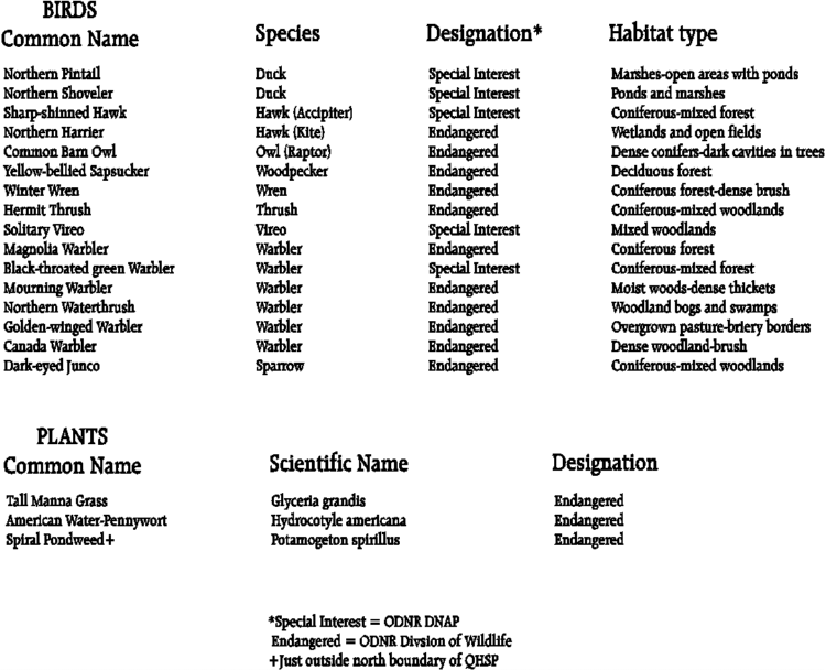
There are numerous bird species that are frequently
found in the wetlands, woods and open fields of QHSP. In addition,
there are endangered plant species that are resident within QHSP (Table
4). Certain species of birds and plants have been identified
as endangered species or species of special interest by the ODNR Division
of Wildlife and Division of Natural Areas and Preserves (ODNR 1993).
Presence of these endangered species at QHSP suggests that
habitats within the park may be critical for their survival. Acquiring
similar habitat types within the BSA might enhance the survival of endangered
species and other QHSP species.
Most of the bird species sighted in
QHSP are migratory, i.e. they are not permanent residents of QHSP.
Migrations are periodic movements of birds from one place to another
following similar routes and returning to the same locality each
time they occur (Grolier 1995). The extent to which animals are migratory
depends upon the foods that they eat, their requirements for reproduction,
and the degree of seasonal climatic change in their environments. The birds
return each year to breed and forage in park habitats. Acquisition
or preservation of additional habitat would likley maintain or improve
the prosperity of migratory and resident bird populations.
The analysis for identifying suitable
habitat and conducting habitat acquisition scenarios began by establishing
a buffer study area (BSA). The [BUFFER] operation in ARCINFO was
used to delineate a matrix of agricultural landuse and wetland habitat
in a buffer area around the park boundary. The buffer distance
was set at .5 mile as an arbitrary distance to establish a reasonable study
area for the thesis. The ARC/INFO [BUFFER] operation
calculated this distance around the boundary of QHSP. The rounded
odd- looking buffer resulted from the shape of the QHSP boundary and the
ROUND' option in the [BUFFER] command usage. This resulting
buffered area (5.7 square miles) was used as a realistic delimiting
area for this thesis. The BSA data layer was used to clip' combined
coverages of the ODNR wetland habitat types and agricultural land
use data from Stark and Portage counties and the USGS DLG coverage.
Selection criteria were developed for
land acquisition or land preservation for QHSP. These criteria were
based on the geographic distribution on ODNR DNAP endangered species data,
and wetland habitat data of Stark and Portage Counties obtained
from ODNR Division of Wildlife. A single bird species, the
Sharp-shinned hawk (Accipiter striatus), and one plant species (Potamogeton
spirillus), were chosen to demonstrate practical examples of the use of
the GIS as a tool for park management and planning (Figure
14) .
7.2 Sharp-shinned Hawk (Accipiter striatus)
The Sharp-shinned hawk is designated
as a bird of special interest' by the ODNR/DNAP. Wildlife
managers need to be able to monitor numerous species in a cost-effective
and efficient method to determine trends in populations that may warrant
management action (Titus and Fuller 1990). A practical demonstration
of the GIS is to use ARC/INFO spatial functions to identify
and differentiate the nesting and foraging habitat used by the hawk.
Riparian or wetland habitats are especially critical to Accipiters
for nesting and foraging (White 1969). Localizing hawk habitats
using the ODNR wetland habitat data might identify areas that
Sharp-shinned hawks use at QHSP for nesting or foraging.
Sharp-shinned hawks have been observed in
two areas of QHSP (ODNR 1994). The sightings information
is descriptive (i.e. qualitative) and refers to areas bounded by QHSP trails.
Area A' is within the boundary of the Coniferous Forest Trail in the northeast
corner of QHSP. This habitat consists of a mature evergreen forest
of White Pine and Norway Spruce. Area B' is the second area
where the hawk has been sighted. This is the boundary of the Meadowlands
Trail, an open area of tall grass meadow (refer back to Map 3).
Nesting habitat for the Sharp-shinned hawk has been identified as being
restricted to coniferous forest in areas of low elevation (Reynolds 1978,
Wiggers and Kritz 1991). The assumption can be made that area
A' is the hawk nesting habitat since it is in the area of conferous forest.
Area B' is assumed to be foraging habitat since it is open meadow.
Hawks are known to hunt and forage for small mammals and birds in open
meadows (Jones 1979). In addition to the Sharp-shinned hawk a second
hawk species, the Northern harrier, has also been sighted in the
Meadowlands Trail area.
The QHSP TRAILS coverage was used to
extract polygons identifying the nesting and forage areas. Using
ARCEDIT all arcs were removed from the TRAILS coverage except those of
the coniferous forest and meadowlands trails. The two remaining areas
were each given a label identifier and topology was re-established
as a polygon coverage (TRAIL_POLY). A character item, HABITAT,
was added to the TRAIL_POLY coverage polygon attribute table (PAT).
Character attributes of NEST' and FORAGE' were assigned to
the area A' and B' polygons described above. The [RESELECT] function
in ARC/INFO was used to create unique polygon coverages of areas A and
B using the unique habitat item in separate queries; e.g. RESELECT
HABITAT = NEST' or HABITAT = FORAGE'. The two resulting coverages
were named HAWKNEST and HAWKFORAGE respectively.
The Sharp-shinned hawk is known to fly
within a 1200 meter distance of it's nesting site to it's foraging area
(Platt 1973). A 1200 meter (3936 feet) buffer (FORGBUF) was created
for HAWKNEST. The resulting area of 2.17 square miles contains
the HAWKNEST coverage area and most of the HAWKFORAGE cover.
Reynolds (1978) notes that Sharp-shinned hawks will challenge intruders
within 100 to 200 meters of their nesting site. HAWKNEST was buffered
at the maximum 200 meters (NESTBUF) to identify an area that may
impact or disturb nesting hawks.
The buffer coverage FORGBUF was used to clip
the ODNR wetland habitat coverage for the BSA resulting in HAWKHAB.
The types of habitats in HAWKHAB are likely utilized by the Sharp-shinned
hawk for foraging and nesting (Map 6). The
habitats within HAWKHAB that lie outside of the QHSP
boundary are likely candidates for acquisition. Further queries
could be conducted on HAWKHAB for specific habitats within nesting
or foraging areas.
7.3 Spiral pondweed (Potamogeton spirillus)
The second analysis identifies the location
of a threatened plant species, Spiral pondweed (Potamogeton spirillus)
and the habitat of shallow marsh on the northern park
boundary. This shallow marsh is classified as wetlands (Wagner
1989). Wetlands are defined as "areas that are inundated or saturated
by surface or ground water at a frequency and duration sufficient to support,
and that under normal circumstances do support, a prevalence of vegetation
typically adapted for life in saturated soil conditions" (Wagner 1989,
Kusler 1992). The shallow marsh habitat is adjacent to similar wetland
within QHSP. Wetlands include swamps, marshes, bogs, wet meadows
and natural ponds (Wagner 1989, Cooperrider et al. 1986).
Natural wetlands have been eliminated in favor of
land development and agricultural use. Loss of wetlands in
Ohio has been extreme over the past 200 years (Dahl 1990, Birch and Wharton
1982). Wetlands act as hydrologic sumps' for pollutants such as
pesticides and agricultural chemicals discharged through ground water (U.S.
Department of the Interior 1976). Numerous plant and animal species
utilize wetlands for habitat. Over half of the areas characterized
as critical habitat by the Endangered Species Act include wetlands (Wagner
1989).
Spiral pondweed is a tuber which refers to
the bulky terminal portion of an underground stem or rhizome of a plant
with modified nodes, buds, and leaves (Wagner 1989). The functions
of tubers are food storage and vegetative reproduction. Pondweeds
are important food plants for ducks, which eat both the nutlets and the
rootstock. Pondweed is a submergent plant species which requires
standing water for habitat.
The point location of Spiral Pondweed
was established from the DNAP data from Natural Heritage endangered species
data. Map 7 visualizes the wetland habitat
where the threatened species occurs. The habitat area of shallow
marsh was identified as an area to be considered for acquisition or preservation
in the Sharp-shinned hawk analysis (section 7.2).
The orthophotos from 1985 and 1995 were used
in this final analysis to visually compare the shallow marsh area
(Map 7). Differences can be observed in the
comparison of the marsh habitat. In 1995 the portion
of the marsh that lies within Quail Hollow State Park appears to be almost
completely dry, whereas in 1985 it is open water. Drainage channels
can be seen clearly. The southern edge of the marsh that lies on
private land has noticeable accumultion of sediments which may be
limiting the flow of water to the marsh within the park. The
drying of the marsh may also be caused by drawdown, which is a naturally
occurring process that allows decompostion of bottom organic deposits,
providing nutrients for new vegetation (Weller 1986).
The shallow marsh is classified as cash-grain'
in the agricultural landuse data. The marsh may be being used for
watering cattle or irrigation. In either instance the marsh may be
susceptible to pollution from pesticides or herbicides used for crop production,
which could induce increased sedimentation and eutrophication (i.e. oxygen
depletion). Options to preserve the habitat are through acquisition
or mitigation with landowners. The marsh might be preserved
as a set-aside' by the owners in exchange for tax reduction or some other
financial incentive.
The usefulnes of the GIS in this example
is the ability to identify critical habitat in relation to park habitats
of similar type using aerial photography. Weller (1986, p.
204) states that "Data need to be gathered and analyzed from this perspective
because acquisition, protection, and management of marshes would
be strongly influenced by this information."