6.1 Maps for Quail Hollow State Park
Maps are valuable tools to display the
completed GIS data layers and the habitat acquisition analysis. The
values of mapping for observation of wildlife habitats (from Kerr 1986,
p.49) are:
1. Show geographic locations of wildlife habitat types
2. Show relationships of types to other types
3. Show community (types of habitat) interspersion
4. Quantify types of wildlife habitat
5. Overlay wildife habitat types with other resource inventories
6. Provide geographic locators in which to to record site-specific
animal occurrence
The GIS database for Quail Hollow State Park
provides information to park management for planning and visualizing the
park environments. Maps produced from basic data layers of roads,
trails, habitats and points of interests depict real-world spatial associations
within the park boundaries. Other maps of wetlands, land use and
soils show the Quail Hollow State Park environment compared
to similar or disimilar areas within the buffer area surrounding the park.
A number of maps were created from multiple
data layers as examples for showing the usefulness of the GIS data.
There are numerous variations and combinations of the layers that could
be used for other demonstration, visualization or map creation. The
ESRI software package ARCVIEW (ESRI 1996) was used for the
final display of maps. ARCVIEW has general GIS capabilites for overlaying
data layers. The user-friendly graphic user interface (GUI) allows
the user to conduct limited spatial analysis as well as the creation
of maps, charts and tables.
Map 1. The
aerial photographs from 1985 and 1995 provides the observer with basic
knowledge of the park area. A number of geographical landscape observations
can be made using the photo. The first observation is that
the park seems to be an island' surrounded by a matrix of residential
and agricultural land use.
A number of roads are parallel to the park
boundaries. For example, Pontius Street borders the park on
the north and lies along the imaginary county line dividing Portage and
Stark county. The theme layer of roads is used throughout the map
displays since it offers the map user an easy reference for the location
of the BSA and QHSP.
Identification and visualization of vegetation
types can be accomplished with the aerial photograph. There are large
areas of woodlands and wetland within QHSP. Within the BSA, woodlands
are interspersed with open fields. Most of the open fields are in
agricultural production or lie vacant for future agricultural use.
Numerous buildings and other man-made structures are clearly visible.
A large lake, Congress Lake, can be seen to the west of the park.
Along the southeast part of the lake is a golf course with the sand
traps clearly visible.
The QHSP road can be seen entering from Congress
Lake Avenue and curving toward the Natural History Study Center.
A large loop off the roadway indicates a parking area, and nearby, a small
pond. Much of the observed vegetation within the park are low areas,
such as marsh, or bog wetlands and dense coniferous woods.
The four GPS point coordinates used for photo registration and orthophoto
correction are also identified.
Map 2. Endangered
species with the DEM. This map shows the location of some endangered
species, and species of special interest within the park. The point
locations of the species of birds are observances made by ODNR
of a single sighting of a species. There are a large
number of endangered and special interest bird and plant species
distributed throughout the QHSP and the BSA (map inset).
The map identifies sightings and locations
of a bird of special interest, the Sharp-shinned Hawk (Accipiter striatus),
and an endangered plant species Spiral Pondweed (Potamogeton spirillus).
These two species are used as examples of the usefullness of the GIS as
a planning and visual tool for park management in the Habitat Acquisition
Model (HAM) analyses in Chapter 7.
The DEM is used to display the topography
of QHSP and the hydrology and open water. The topography in
the DEM has been exagerated by a factor of 1.5 times.
This exageration is necessary because elevations are very moderate within
QHSP (1130 feet to 1220 feet). Visualizing topography and riparian
areas such as the shallow marsh on the north boundary of QHSP may be useful
for wetland and/or habitat analysis. Visualization of habitats
may also be valuable for land acquisition or preservation considerations.
Map 3. Points of interest
overlayed with trails. This map provides the visitor to QHSP with
a visual perspective of trails for walking and horseback riding.
Two main parking areas are identified and the park road leads to the Natural
History Study Center. The trails in the park are identified with
varied line symbols and colors. The Bridle Trail begins near the
parking lot loop where horses can be off-loaded from trailers. The
Hiking Path Trail begins at the parking lot loop and leads to the Natural
History Study Center. Points of interest near the study center are the
Herb Garden and picnic area. The path continues, intersecting
the Deciduous Forest and Coniferous Forest trails and leading to the large
pond at the north boundary of the park. It returns south through
the park with a loop to the Bird Blind, onto a smaller pond and finally
ending at the loop parking area. This map is a useful tool for
recreational users of QHSP. Visualization of areas bounded
by trails can also identify habitat of various birds and animals.
6.2 Maps of the Buffer Study Area (BSA)
Map 4. Agricultural
and residential landuse in the BSA. In this map the location of the
park can be seen relative to the buffer study area (BSA) which contains
most of the city limits of Hartville, Ohio. Due to lack of complete 1995
aerial photography from the ODNR the 1985 othophoto had to
be used for the visualization of the entire BSA. The map identifies
the transportation network of roads within the buffer study area.
The roads layer is used in most maps because it offers a reference for
the map user. The road system within the town of Hartville
can be observed in the southwest corner.
Data from Portage and Stark counties include
the agricultural landuse within the BSA. The largest areas of agricultural
landuse are in Agricultural-Vacant and Cash-Grain. There is a substantial
amount of residential landuse. There were large amounts
of missing information from the Portage and Stark county data.
Map 5. ODNR wetland
habitats in the BSA. The wetland habitat data from the ODNR Divison
of Wildlife ERDAS data are visualized in this map. Presence
of endangered species at QHSP suggests that habitats within the park
may be critical for wildlife and plant species survival. Acquiring
similar habitat types within the BSA might enhance the survival of endangered
species and other QHSP species.
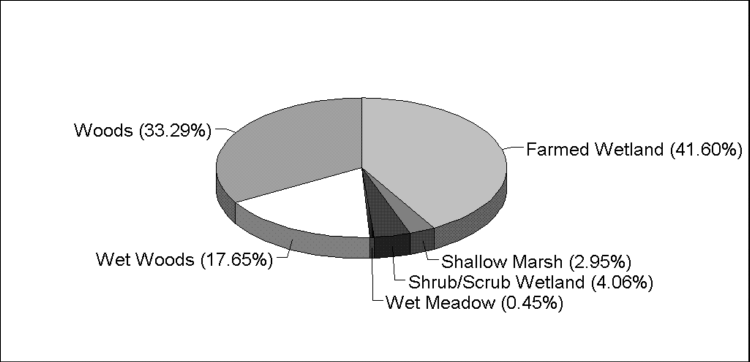
Fifty percent of the BSA is woods and wet
woods habitats (Figure 13). These areas
are important for nesting for numerous bird species. Shallow marsh
wetland is preferred nesting for many duck species as well as habitat for
frogs and other reptiles. Shallow marsh wetland is also important
for nutrients for many plant species including Spiral Pondweed, an endangered
plant that thrives in the shallow marsh on the north boundary of QHSP.
Wetland habitats can be identified by query
and spatial analysis of the ODNR wetland data. Maps and queries of
the data are incorporated into a Habitat Acquisition
Model (HAM) discussed in the following chapter.